- 24/7 Emergency Response - Call Now!
- Stop The Damage Before Mold Forms
- Our Home Inusurance Claim Experts Are Ready
- Learn How We Help Families With Water Damage
 Call us 877-451-9251
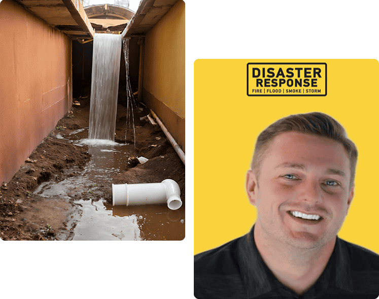
Water Damage Restoration in Boca Raton, FL
Owning a home or business is one of the hallmarks of living the American Dream. While there are many fulfilling and positive aspects of owning property, one of the challenges that owners face is property damage. This type of damage can be caused by a range of disasters, both man-made and natural. Of all the types of property damage, water damage is among the most common.
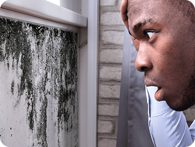
Whether from broken pipes or heavy thunderstorms, it doesn't take a professor from Florida Atlantic University in Boca Raton to know that water damage can be incredibly harmful to your home. Water can spread quickly throughout your property, causing damage to furniture and porous materials as it moves. In the blink of an eye, you could be looking at substantial rotting, warping, and even mold growth. That's why water damage restoration in Boca Raton, FL is so important - to mitigate the damage to your home and help prevent it from happening in the future.
Trying to overcome flooding and other water-related disasters on your own can seem like a lost cause. But with Disaster Response by your side, you don't have to lose hope. As a local water damage clean-up company, we provide comprehensive restoration services to properties of all sizes in Boca Raton. From the first time we assess your water damage to the time we mitigate and restore, we're here for you.
Fire Damage for Ben Leeper
Mold Remediation for hlsmith0814
Sewer Backup for Lisa Beadle
Soot Removal for Edd Bowen
Water Damage for Tonya Luvisch
Fire Damage for Taryn Connell
Mold Remediation for Karen Romonouski
Sewer Backup for Amanda Shohoney
Soot Removal for arlene tortorello
Water Damage for Meagan
Fire Damage for Kala Doyle
Mold Remediation for Joan Campbell
Sewer Backup for Shannon Wade
Soot Removal for Sharrn
Water Damage for Tracy Farah
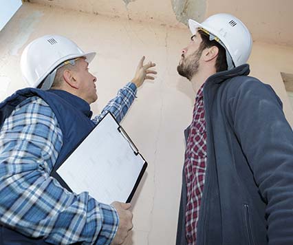
Dealing with property damage can be overwhelming. You're likely concerned about a few key things:

Navigating the insurance claim process
We guide you through every step, ensuring you understand the process and get the most out of your claim.

Scheduling for a quick and quality completion
We provide a clear timeline for restoration, prioritizing both speed and quality, so you can get back to normal as soon as possible.
You might also be thinking about:

Ensuring the safety and health of your family or employees during the restoration: Our team takes all necessary precautions to protect the safety and health of everyone involved, using the latest techniques and equipment.

Understanding the full scope of the damage and what needs to be done:We conduct a thorough assessment of the damage and provide a detailed plan of action, so you know exactly what to expect.

Knowing the costs upfront and avoiding unexpected expenses: We provide transparent pricing and a detailed estimate before any work begins, so there are no surprises along the way.

Preventing future issues, such as mold growth or structural problems: We don't just fix the visible damage—we address the root causes to prevent future issues, giving you peace of mind.

Protecting your belongings and valuables from further damage: We take extra care to safeguard your possessions during the restoration process, minimizing any further impact.


Minimizing disruption to your daily life or business operations: We work efficiently and flexibly to reduce the disruption to your routine, allowing you to continue with your life or business as smoothly as possible.

Finding a trustworthy team to handle your property with care: Our experienced and highly-trained professionals treat your property as if it were their own, ensuring the highest standard of care.

Ensuring the job is done right the first time: We pride ourselves on doing the job right the first time, using industry-leading techniques and thorough quality checks to ensure lasting results.

Receiving clear communication and updates throughout the restoration process: We keep you informed every step of the way, providing regular updates and clear communication, so you're never left in the dark.

Ensuring the safety and health of your family or employees during the restoration: Our team takes all necessary precautions to protect the safety and health of everyone involved, using the latest techniques and equipment.

At Disaster Response, It's All About You
Like The Schmidt Boca Raton History Museum in Boca Raton, Disaster Response has been a pillar of the community for years. As a second-generation disaster response company, we know that our work is never about us. At its most basic, it's always about you—your situation, your needs, and your satisfaction. We engineer our processes to help you quickly recover from water floods and disasters. Our total focus is on you, our valued customer. And that, in a nutshell, is what makes Disaster Response one of the most trusted and highly-rated water restoration companies in Boca Raton.
Instead of focusing on profit, bottom lines, and yearly projections, we make you our priority. That's why we're serious about providing expert-level disaster preparedness and response services when you need them the most. Could you imagine trying to decipher misleading fine print or dealing with a pushy salesperson when you're just trying to get your life back together? That's not the Disaster Response way, and it never will be.
We don't just clean up after water leaks, floods, or other disasters; we go above and beyond by providing a consultative approach that serves you for years to come. We assist you in dealing with insurance adjusters to ensure you get the coverage you deserve without unnecessary delays. We make it a point to meticulously review every detail of your claim and work hard to make sure adjusters understand the full extent of your losses. We can also provide guidance on how and when to engage a public adjuster to bypass inefficiencies in the insurance process. At the end of the day, we strive to provide peace of mind during your difficult time and work tirelessly to get your property back to its pre-loss condition.
The Disaster Response Difference

Professional Technicians, Technology, and Processes
In fact, we'll dispatch a team of water disaster technicians to you within three minutes. We'll also advise you on what can be done to minimize the water damage in your home or business. Our water damage restoration team will use cutting-edge technology and IICRC-approved methods to restore as much of your property as possible.

Insurance Advocacy
Disaster Response works one-on-one with you and your insurance provider to expedite the claims process and get your home back to normal as soon as possible.

Satisfaction Guaranteed
We're proud of our work and stand behind every project we complete. Our goal is to exceed expectations and provide peace of mind throughout every step of your water damage restoration process. If you're not satisfied for any reason, we'll listen to your concerns and work tirelessly to rectify any issues that need addressing.

Your Guide to Water Damage Restoration in Boca Raton, FL
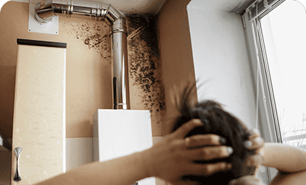
Water damage restoration is a key step in remediating damage to your home, both structurally and aesthetically. Damage from water doesn't just affect the walls, floors, and ceilings in your home. It can also cause deeper issues that, when untreated, can weaken your foundation significantly and lead to long-term instability.
As if that weren't enough, water damage can present health hazards to your friends, family, and pets. Mold and bacteria can grow in damp areas after water incidents, causing allergies, respiratory problems, and even visits to The Meridian at Boca Raton in Boca Raton for examination. Ignoring water damage can also result in irreversible harm to your belongings, including furniture, electronics, and sentimental items, leading to financial loss and emotional distress. Professional water clean-up services can repair the damage to your property, help protect valuable assets, and re-establish your home or business as a safe, healthy environment for occupants.
What Makes Our Water Damage Company in Boca Raton, FL, Different from Others?
One of the most common questions we get at Disaster Response is, "What separates you from other water damage clean-up companies in Boca Raton?" The first and easiest answer to that question centers around our commitment to customer service. We hold our clients in high regard because, without them, there would be no Disaster Response. As such, we work tirelessly to provide them with quality work from friendly and helpful technicians, regardless of the size of their home or business.
But that's just the start. Our clients recommend friends and family to our business because we prioritize the following:

Cost
Investing in damage restoration for your home is a smart move that can help reduce long-term costs. The best part? Our services are covered by insurance companies, so there's less worry about paying out of pocket.

Technicians
Every member of our team has years of experience, specialized training, and certifications in handling water damage. We prioritize our customers' well-being and meticulously attend to every detail to prevent any potential mold-related issues in the future. From single-family homes to
Time
Water disasters happen quicker than you might think. One moment, you're enjoying family time at Sugar Sand Park in Boca Raton. The next, you're pulling in your driveway to a flooded home. When you call our office, we'll get to work assessing the cause of your water damage and how extensive the water damage is in your home or business. From there, we'll dispatch a team of IICRC water damage restoration experts to your location.
Tools
Disaster Response has made significant investments in cutting-edge water damage equipment, including inspection tools that enable thorough water removal. Our technicians have undergone extensive training to operate these machines and know when and when not to use them.
Process
For over 40 years, we have been helping with water damage issues, refining our process along the way. We can quickly find hidden damages that others might miss and document everything for your insurance company.

Reliable Water Damage Restoration Network
We aren't afraid to ask for help if it means a safer, more enjoyable environment for your family or customers. In fact, we have access to a network of industry pros who are experts in a range of water damage services. To make your life a little easier, we also work with insurance professionals who assist with the claims process.
What Does Disaster Response Fix?
As an IICRC-certified water damage contractor in Boca Raton, FL, our technicians can address several areas of your home or business that have been damaged by a water disaster.
- Floors: It's very important to take the necessary time and steps to effectively dry your floors to prevent any potential water damage and mold growth in the future.
- Walls: Depending on the amount of water that enters your business or home, the structural integrity of your property may be at stake. Our technicians will evaluate the situation, inspect your property, and replace materials damaged by water.
- Rugs: If your rugs get wet during flooding or from another water disaster, they may be salvageable. We'll work hard to save all the rugs in your property.
- Furniture: Your furniture is probably expensive and may hold a certain level of sentimental value. Instead of throwing it away or donating it to Old Floresta Historic District in Boca Raton, we can repair and restore it.
Disaster Response specializes in every kind of damage caused by rain, wind, or snowstorms. We handle water damage, mold, mildew, and more, and can be at your home or office within an hour of your call to assess the situation and put a water damage restoration plan into action.
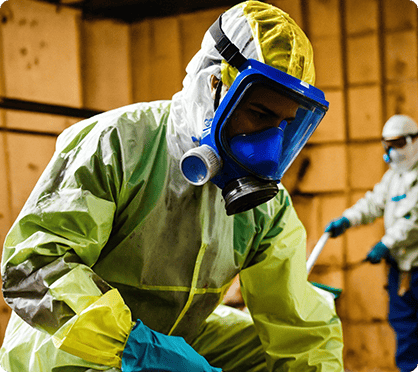
What Tools Does Disaster Response Use for Water Damage Clean-Up?
We only use the best equipment! With our extensive experience in the Boca Raton restoration industry, we've acquired state-of-the-art tools designed to tackle a wide range of challenges. This experience has also allowed our technicians to identify which type of equipment is best for a particular situation. Some of the most common water damage restoration tools we use include:

Infrared Cameras
Our infrared cameras give us the ability to see moisture in walls and ceilings that is not visible to the naked eye, almost like having "X-ray" vision. This capability allows us to detect and address trapped and hidden humidity, significantly reducing the risk of mold growth.

Moisture Meters
We use moisture meters to measure moisture levels in cellulose material. Before and after the drying process, we will conduct moisture readings in all areas of your property. If we detect moisture in an unaffected area of your building, we'll get to work quickly to dry it.

Air Movers
This equipment is designed to work in conjunction with our dehumidifiers. While our dehumidifiers extract moisture from the air and convert it to a liquid, our Air Mover helps to circulate this moisture in the air so that the dehumidifier can effectively remove it.

Ozone Generators
These advanced tools enable us to cleanse affected surfaces and the air in a more effective manner. Ozone Generators work by causing oxygen molecules to implode, making them a valuable deodorization tool.

Xtreme Xtractor
This tool is great for tackling tough moisture after water damage. It allows us to apply direct pressure to a surface, like a carpet, that has soaked up water. The pressure helps draw out the water, making it easier to remove.
Top 3 Types of Water Damage You Should Know About
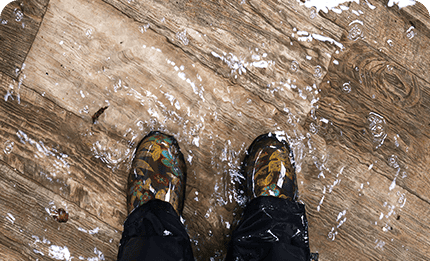
Water damage can strike without warning and can wreak havoc on your property, leaving you feeling hopeless and overwhelmed. Whether it's from a burst pipe, a severe storm, or an overflowing appliance, your property needs immediate water damage clean-up in Boca Raton, FL, to prevent further harm. Here are the top three types of water damage you should know about:
Clean Water Damage

This type of water damage happens from a "clean" source, such as rainwater or a broken pipe in your home. It's easier to clean up than others on this list but can still cause extensive property damage when ignored.
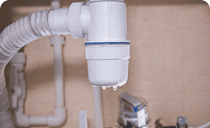
Gray Water Damage

Gray water damage stems from appliances such as toilets without feces, washing machines, and dishwashers. Gray water sometimes contains bacteria and contaminants that can make you or your family sick.
Black Water Damage

The name alone indicates the severity of this type of water damage. It's caused by backed-up sewer lines, river flooding, and standing water that supports bacteria growth. Black water presents serious health hazards and needs to be handled by professional water damage contractors.
If you suspect your home or business has been damaged by one or more of the types of water above, take the following steps:
- Be Safe: Turn off all electricity running through your property. Don't go near or touch any water you believe to be contaminated.
- Stop the Source of Water: If you're able, put a stop to the water at its source. That way, you can prevent more damage.
- Call Disaster Response: Contact our water damage company ASAP for water restoration services. Our team is available 24/7 to respond to emergencies.
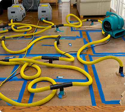
Our Process for Water Damage Restoration in Boca Raton, FL
Having a water damage restoration company by your side who knows how to remediate moisture is a key factor in getting your life back on track. At Disaster Response, we have refined our process over 40+ years of water damage clean-up experience. That way, we can provide customers with reliable, comprehensive service when they need it the most.
We utilize powerful pumps and vacuums to eliminate standing water from your property. Swift water removal is essential in minimizing damage and lowering the likelihood of mold growth. Our team is dedicated to ensuring efficient water extraction to prevent any additional complications.
After extracting water from your property, we dry and dehumidify the impacted areas. We use industrial-grade dehumidifiers and air movers to do so to eliminate moisture from walls, floors, and furniture. Proper drying helps prevent warping, swelling, and the growth of mold.
Whenever we deal with water damage, we have to address the potential contaminants and bacteria that can enter your home. We make sure to thoroughly clean and sanitize all affected areas to create a safe living environment. This involves cleaning carpets, upholstery, and personal belongings. Our technicians also use antimicrobial treatments to prevent mold and bacterial growth.
The final step in the process is the restoration of your home to its pre-damage condition. This comprehensive restoration process may encompass a range of tasks, from minor repairs such as replacing drywall and installing new carpeting to major reconstruction efforts. Rest assured that Disaster Response is fully equipped to manage all aspects of water damage restoration, from start to finish.
- Maintenance: Have your business or home's roof, appliances, and plumbing inspected by professionals to spot early signs of wear and tear.
- Water Alarms: If there is a flood or leak in your home, a water alarm can alert you so that you can take action immediately.
- Drainage: Your home needs proper drainage systems in place at all times. To prevent water buildup, be sure to unclog your downspouts and gutters.
- Cracks and Gaps: Be sure to seal up any cracks and gaps in your property's foundation to limit water from getting inside.

The Water Damage Company in Boca Raton, FL, You Can Trust
When you want a great steak, you don't go to a fast-food joint and expect a filet. You go to a TwentyTwenty Grille in Boca Raton. When you need quality disaster response services from licensed professionals, you don't go to a fly-by-night shop. You contact Disaster Response.
As a local water damage clean-up business, we believe that providing clients with effective service that they can rely on in times of stress is of utmost importance. While some of our competitors prioritize profits over people, you can rest easy knowing we care about you - and that's something you can always count on when you choose our water damage company.
Whether a pipe has burst in your commercial space and your showroom is flooding, or your home has standing water from a Boca Raton rainstorm, we're here for you 24/7. Contact our office to learn more about the Disaster Response difference or to schedule an inspection for your property today.
Contact Your Emergency Disaster Response Now!
Latest News in Boca Raton, FL
Diane Dalton, Boca Raton, FL Community Remembers a Cherished Family Matriarch
ompaix.comhttps://ompaix.com/news/diane-dalton/
Diane Dalton, Boca Raton, FL—Diane Dalton has passed away, leaving her family and loved ones in profound sadness. Diane’s passing on Friday, October 25, 2024, came after a recent battle with stage four lung cancer, diagnosed in early September following a hospitalization for pneumonia. Her journey through illness progressed quickly, with her granddaughter Amber Gosney by her side, providing devoted care and companionship.Amber, who shared a deep connection with her grandmother, has been at the forefront of managing Diane&r...
Diane Dalton, Boca Raton, FL—Diane Dalton has passed away, leaving her family and loved ones in profound sadness. Diane’s passing on Friday, October 25, 2024, came after a recent battle with stage four lung cancer, diagnosed in early September following a hospitalization for pneumonia. Her journey through illness progressed quickly, with her granddaughter Amber Gosney by her side, providing devoted care and companionship.
Amber, who shared a deep connection with her grandmother, has been at the forefront of managing Diane’s final arrangements. Diane had spent her last days under the compassionate care of VITAS Hospice, whose staff, particularly Nurse Amy, provided her with comfort and dignity in her final hours.
Diane lived on a modest income, and Amber has been handling the associated expenses, including moving her grandmother’s belongings from her apartment. To support these efforts, Amber organized a fundraiser on October 28, 2024, hoping to ease the financial challenges of honoring her grandmother’s memory. So far, $2,705 has been raised from 29 generous donations, including a recent $50 donation from Anaïs Devereaux and a substantial $500 contribution from Sarah Hall, the fundraiser’s top donor.
READ ALSO: Hanna Perla
Diane Dalton’s memory will be cherished by all who knew her, and her legacy of kindness and love will be carried forward by her family and friends.
We extend our heartfelt prayers to Diane’s family during this difficult time, hoping they find peace and comfort in her memory.
READ ALSO: Alicia Yaya Sanchez
Short Summary of Diane Dalton
| Aspect | Details |
|---|---|
| Name | Diane Dalton |
| Date of Passing | October 25, 2024 |
| Fundraiser Created By | Amber Gosney |
| Goal Amount | Not specified |
| Amount Raised | $2,705 |
| Location | Boca Raton, FL |
| Purpose | Final expenses, including moving belongings from her apartment |
PLEASE VISIT: GoFundMe for Diane dalton
Note:This post was written and edited by Lucas Harris, based on their expertise and research. It is intended for informational purposes only. It does not constitute legal advice. We welcome your feedback and questions on this content. Please feel free to contact us.
The 5 best luxury hotels in Palm Beach and Boca Raton, Florida
Jackie Caradoniohttps://m.economictimes.com/magazines/luxury/the-5-best-luxury-hotels-in-palm-beach-and-boca-raton-florida/articleshow/114847283.cms
Luxury hotels and resorts in Palm Beach and neighboring areas are experiencing significant renovations and new developments. Key projects, including the Palm House, The Vineta, and The Boca Raton, are set to open or complete renovations in the near future. These additions aim to cater to the growing wealth and tourism in south Florida.If a few blocks of Collins Avenue in Miami Beach are currently commanding some $2.5 billion in ...
Luxury hotels and resorts in Palm Beach and neighboring areas are experiencing significant renovations and new developments. Key projects, including the Palm House, The Vineta, and The Boca Raton, are set to open or complete renovations in the near future. These additions aim to cater to the growing wealth and tourism in south Florida.
If a few blocks of Collins Avenue in Miami Beach are currently commanding some $2.5 billion in hotel investment, it doesn’t take a lot to imagine how much more money is being pumped up and down the south Florida coast. Include hospitality-driven real estate developments slightly farther inland from the A1A coastal highway, and the total likely reaches 11 figures. New builds in the area have come fast and furious in recent years, catering to a wealth boom that has made south Florida a national power center. As a result, the boundaries between neighborhoods have blurred, with Miami, Bal Harbour, Fort Lauderdale, Boca Raton and Palm Beach now forming an almost continuous (and continuously luxurious) seaside strip.
But one key difference between the southern and the northern ends of it is that several of the Miami projects will be under construction for years to come, while Palm Beach is preparing to cut ribbons on most of its notable openings this winter.
Here, a look at five new and recently renovated escapes “up north” worth adding to your next visit.
Palm House
London-based Iconic Luxury Hotels (whose grand UK properties include the stately Cliveden House and Chewton Glen) is crossing the pond and heading straight for Florida, where it’s reinventing a long-shuttered 1960s icon on Royal Palm Way. The 79-room property—expected to open fully in January, with a soft opening in November—is done up in classic Palm Beach style, with floor-to-ceiling seashell tapestries in the lobby, Slim Aarons photographs lining the hallways and frilly pink umbrellas and striped cabanas surrounding the pool. The guest rooms further honor the Palm House’s heyday with plenty of coral-and-green art deco touches. But the food options promise to be more global, with a Nikkei (Japanese-Peruvian) concept set to fill the Palm House Dining Room.
The Vineta
This Mediterranean revival building is nearly a century old, but now the Palm Beach landmark is getting a new lease on life as an Oetker Collection hotel, making it a sibling to the decadent Le Bristol in Paris and Eden Rock in St. Barts. It will reopen in the first quarter of 2025 with carefully preserved details—especially in the revived Leopard Lounge, a favorite celebrity haunt of the 1950s—and 41 refreshed guest rooms. The company has been tight-lipped about details, resting on its sterling reputation to build buzz, but one thing is for sure: A Mediterranean-inspired restaurant will add a little extra glitz to the original palm-lined pool. And it’s all a stone’s throw from tony Worth Avenue.
The Breakers
Palm Beach’s old-money mainstay has invested in a handful of updates of its own, adding a new $12 million recreation facility for tennis, padel and pickleball and reopening its exclusive hotel-within-a-hotel, the Flagler Club. The latter will have 21 guest rooms renovated by Tihany Design, which is adding details such as embroidered wall coverings, trompe l’oeil-style moldings and a coastal color palette to bridge the Breakers’ iconic Italian Renaissance architecture with the resort’s breezy beachfront location.
The Boca Raton
It technically isn’t Palm Beach, but it sure is close. And in December, Boca Raton’s legendary private club will introduce a $120 million transformation of its Beach Club resort with 210 marble- and velvet-clad guest rooms. It’s the last part of a four-year renovation to the broader Boca Raton resort complex—356 acres in all—which has cost some $300 million and aims to emulate the mega success of Bahamian tourism juggernaut Baha Mar. At the Beach Club, three new restaurants will include Mediterranean all-day concept Marisol and the toes-in-the-sand Onda. Guests will also be able to take pink Vaporina-style long boats across the Intracoastal Waterway to the Boca Raton’s main campus, which has 706 rooms and suites across four hotels, plus a golf course, 14 restaurants, a racquet club and a sprawling pool complex with a lazy river.
One to watch: Eau Palm Beach Resort & Spa
This 1950s icon was recently acquired by billionaire Larry Ellison, whose growing hotel portfolio includes Nobu Ryokan Malibu and Four Seasons Resort Lanai. The Oracle Corp. co-founder bought the resort for an undisclosed amount, according to a statement. Though it appears to be business as usual for now at the seven-acre beach resort, Ellison has brought in a Nobu pop-up for the winter season. More updates are surely on the way for 2025.
Read More News on
luxury hotelsPalm BeachBoca Ratonhotel investmentIconic Luxury Hotels
(Catch all the Business News, Breaking News, Budget 2024 Events and Latest News Updates on The Economic Times.)
Subscribe to The Economic Times Prime and read the ET ePaper online.
...more
Featured in movies, TV's 'Seinfeld', iconic New York City bagel shop opening in Boca
Eddie Ritzhttps://www.palmbeachpost.com/story/entertainment/dining/2024/09/27/featured-seinfeld-tv-show-hh-bagels-shop-opens-boca-raton-florida/75407112007/
Bagel lovers get ready to rejoice, H&H Bagels will be opening on Wednesday, Oct. 2 on Glades Road in ...
Bagel lovers get ready to rejoice, H&H Bagels will be opening on Wednesday, Oct. 2 on Glades Road in Boca Raton.
To say that the anticipation for this purveyor of authentic New York City bagels has been growing would be putting it mildly.
H&H Bagels director of marketing Jesse Stein said they've been flooded with inquiries about the new restaurant saying "One of the most popular comments on our Instagram account is 'When is Boca opening?'"
With seven locations in New York City, Boca Raton will be the iconic bagel shop's first franchise and first-ever restaurant outside of the city.
'Famous' H&H Bagels featured in movies, TV's 'Seinfeld'
Featured in many movies and television shows including "Seinfeld," "The Office," "Sex and the City," "Entourage," "You’ve Got Mail," "How I Met Your Mother," and many more, this shop is a New York City classic and a bagel lover's dream.
Need a break? Play the USA TODAY Daily Crossword Puzzle.
Founded in 1972, H&H Bagels has stayed true to their original recipe and the same proven techniques since they opened.
H&H Bagels' menu at Boca Raton shop
Using high-quality, simple ingredients, their bagels are proofed, kettle-boiled, bathed in cold water, and then oven-baked fresh to perfection. Baked on-site all day, customers are able to choose from a wide variety of classic spreads, egg sandwiches, smoked fish, and specialty sandwiches.
On opening day, in addition to offering South Florida true New York City bagels, they will be giving away H&H Bagel tote bags to the first 200 customers. Within each bag will be a gift cards to the store ranging from $5 to $100.
To celebrate the opening of the Boca Raton location, both H&H Bagel CEO Jay Rushin and director of operations Ryan Klepper will be at the ceremony.
Following the opening in Boca Raton, several more franchises are expected to follow. "Next we'll open in Santa Monica, likely in late October or early November," Stein said. After that, he said shops in West Palm Beach's NORA District and other Florida locations including Tampa and Jacksonville will follow in early 2025.
Stein said the company is "incredibly excited to finally open their first location outside of the city and to bring New York City bagels to the Boca community."
H&H Bagels opens in Boca Raton
Where: 2200 Glades Road, Boca Raton
Hours: 6 a.m. to 4 p.m. seven days a week
Information: 561-465-3752; hhbagels.com
Eddie Ritz is a journalist at The Palm Beach Post, part of the USA TODAY Florida Network. You can reach him at eritz@pbpost.com. Help support our journalism. Subscribe today.
SEXUAL PREDATOR NOTIFICATION
Newshttps://www.bocaratontribune.com/bocaratonnews/2024/11/sexual-predator-notification-5/
Police NewsSEXUAL PREDATOR NOTIFICATIONLess than 1 min.ReadHot this week Advertisement...
Police NewsSEXUAL PREDATOR NOTIFICATION
Less than 1 min.Read
Hot this week
Advertisement
Topics
Advertisement
Related Articles
Police News 11/01/2024
Police News 11/01/2024
Police News 11/01/2024
Police News 10/31/2024
Police News 10/31/2024
Advertisement
Advertisement
Previous article
Tropical Systems Brewing in the Caribbean: Boca Raton, Delray, and Boynton Beach Urged to Stay Alert
Next article
The Ultimate Checklist for Freshmen Entering University
EDITOR PICKS
11/01/2024
10/28/2022
10/12/2010
POPULAR POSTS
10/28/2024
10/30/2024
10/25/2024
POPULAR CATEGORY
The Boca Raton TribuneThe Most Reliable Source of Boca Raton News
The Boca Raton Tribune has been a cornerstone of local journalism for over 18 years, delivering reliable news and engaging content to the Boca Raton community. Our commitment extends across print, online platforms, and video interviews, reflecting our dedication to comprehensive coverage. We actively support local events, an non profit organizations. We value our readers and partners, ensuring we remain a trusted source of news and community connection.
Contact us: info@bocaratontribune.com
Buiilt by Heizer Marketing
Disclaimer: